Showing posts with label wyoming. Show all posts

Friday, August 1, 2025

Yellowstone Falls Movies Part 2

Before we start... Kim reminded me that you can click on the photos and videos and they'll come up much larger which makes them more impressive. Then, just click the X in the upper right to close and go back to the entry.

On with the Show!

These videos and photos are of the Lower Yellowstone Falls in the Grand Canyon of the Yellowstone. 

This is the more spectacular one of the two, mostly because it's drop is way longer (taller?). 

The river is the Yellowstone River which comes out of the very large Yellowstone Lake (are we seeing a pattern here?). Yellowstone River flows into the Missouri River, which flows into the Mississippi River and eventually down into the Gulf of America. An amazing journey.

Here's a great shot from Google Earth showing the vast canyon looking upriver towards the Lower Falls that shows how steep the canyon is.


And a photo that was taken from Artist's Point on the south side. 


One from the north side of the canyon. It's pretty impressive. 


In order to get way down to the Observation area, there's a trail called...The Brink of Lower Falls Trail.

Here's where the trail ends up so you can look over at the falls.

Part of the trail heading down

Going up was much more of a challenge

You can see how crowded it gets at the railing. I like to keep my distance from other people when looking of the edge.


It's a steep, 0.7-mile out-and-back hike that offers breathtaking views of the Lower Falls and the Grand Canyon of the Yellowstone.
Length: Approximately 0.7 miles (1.1 kilometers) round trip.
Elevation Change: The trail descends about 600 feet (180 meters) over a short distance, making it a steep hike. 
Difficulty: Generally considered moderately challenging due to the steepness, especially on the return hike. 

The darnest thing about the trail is the footwear people wear. I saw open toed sandals, flip-flops (!), lots of crocks, flat lady's shoes. Amazing. I did notice that those people went slower than most.

So, here's some videos of the river and the falls.


A LOT of water going over !!


And...just a few extra photos thrown in here for your enjoyment.

This is what is called a "Bison Jam"


Here's the cause.

We could probably put out a dozen entries on Yellowstone alone, but this will have to do it for now. 

We stayed a week and covered only a fraction of the park. It does get very crowded, so we entered before 7 every morning. After that time, the line backed up for miles, even before the entry.

steve/kim/katie


Monday, June 30, 2025

A 200-mile day trip in Wyoming

 While in Cody, Wyoming, we decided to take a short day trip along the Chief Joseph Byway. Little did we know that it would turn out to be so spectacular and LONG! But well worth it.

Here's the location in Wyoming and the route we took.

As you can see, this route is located in the way NW part of Wyoming and borders Yellowstone Park.

You can see the Start and Finish point in the lower right in Cody.

The start of the Chief Joseph Byway starts innocently enough then...

...here's what we found.  Oh, and we did this in our Ram 1500, NOT the motorhome.


This is only a part of the view from the top before heading down.


Cooke City. Old, old mining town. A long way from civilization. Look at those steep mountains in the background!

What is a WOOKA?


We saw a number of cars stopped along the side of the road and instantly that something was up ahead.
We have never seen a Grizzly Bear before, and now here's two!

It's as if he's saying, "What are you lookin' at?"

Look at the snow levels still in June.


Kim took some fabulous photos !


Now, for some scenic views. Again, these are all Kim's photos, most were taken while we're driving !


This is a great shot!

As is this one.

This valley along the Beartooth Highway was formed by glacial action.

This is the barrier fence at the bottom to catch any rockslides from the photo below.

You can see the slide from the top that occurs over and over again and the barrier at the road below.

This is Heart Mountain along the 75-mile trip back home after leaving the mountains. It was formed millions of years ago by a landslide from the surrounding mountains! It's over 8,000 ft tall. The geology is mind-boggling.


Anyway, you can see why we included so many photos. Kim and I ended up with over 500 photos. 

A spectacular day-long 200-mile trip in NW Wyoming. If you're ever in the area, be sure to take this journey.

steve/kim/katie

Katie is feeling shy.


Sunday, June 15, 2025

Devil's Tower, and more Wyoming sites

Rather than a blog entry for each stop, this is an entry with LOTS of photos from our travels over the previous months.


DEVIL'S TOWER, WYOMING

Amazing lava dome in NE Wyoming that is left over after years and years of erosion of the topsoil around it.

WYOMING COAL TRAINS


Four tracks with coal cars loaded with coal from the Wyoming coal mines. Two going in each direction. One loaded, one returning empty. All day and night. Over 100 cars each. Amazing production.

AYERS NATURAL BRIDGES


Sweet little park with a natural bridge over a stream and small lake. 


SACAGAWEA GRAVE SITE
When we planned this summer's route, I thought it would be interesting to visit this gravesite. Over the years, we've visited a few memorable grave sites like Shoeless Joe Jackson, Hank Williams Sr., Steve Prefontaine. All of them very moving.


FANTASTIC WYOMING CLOUDS

Every day we had clouds like this....stunning.


WIND RIVER CANYON
We've gone through this canyon before in years past. It's about 25 miles long. But each time we've done it, we're in the motorhome and it's very difficult to pull over to take it all in as well as to take any photos. This time, we travelled in our pickup and took our time. It's really an amazing canyon between Shoshoni and Thermopolis, Wyoming. 


You can see the semi-truck and cars in the distance for scale. 

Some of the rocks here are over a billion years old. This whole area got lifted up around 75 million years ago. Same time as the Rockies were formed. 


We'll try to keep our travels more up to date as we've been to the Big Horn Mountain, Big Horn Canyon, the city of Cody, the Chief Joseph Byway, the Beartooth Highway, Heart Mountain and Yellowstone already. In the meantime, please enjoy this one.

Steve/Kim/Katie

Having a ball. Over 15 years of travel and not tired of it yet.


Tuesday, December 31, 2013

Devils Tower in Wyoming

The Close Encounters of the Third Kind movie. We've all seen it right?


Well, this is the tower that is where the climax of the movie took place so we went there expecting to be able to climb to the top. Wrong. Here's the only way to get to the top....


Of course, you could "climb" to the top using the scale model in the Visitor's Center....


Seriously, this is an amazing tower/mountain/rock. As we drove to it, we got a quick glimpse of it in the distance.


...and ever closer....these buffalo and cows cooperated perfectly.


As you enter the park, you drive around the back side (or west side) where you can take a guided hike (or your own hike) around the base of the tower. It's rather spellbinding...you cannot take your eyes off of it.


This is looking east from the Visitor's Center...pretty cool huh?


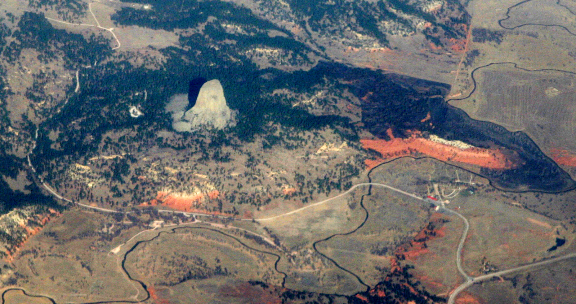
Here's a great aerial photo showing where it's located in the surrounding area.


Looking from the east. The sun is already on the west side so you only see it here in the shade.


As we walked around, the ranger pointed out a very large part of the tower that had broken off.


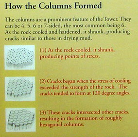
The columns themselves are very interesting....check out this poster.
Yikes !

This is what the base of the tower looks like....all the rocks that have fallen over the centuries. Can you imagine how large this tower used to be?

You are allowed to climb over the rocks to get to the base but it's rather difficult and takes a LONG time.

One last view looking straight up. 

So..how was it formed? There are several theories....you can read them here if you're interested....

How the Tower is Formed: An Ongoing Debate

Geologists agree that Devils Tower was formed by the intrusion (the forcible entry of magma into or between other rock formations) of igneous material. What they cannot agree upon is how that process took place and whether or not the magma reached the land surface.

Numerous ideas have evolved since the official discovery of Devils Tower. Geologists Carpenter and Russell studied Devils Tower in the late 1800s and came to the conclusion that the Tower was indeed formed by an igneous intrusion. Later geologists searched for more detailed explanations.

In 1907, scientists Darton and O’Hara decided that Devils Tower must be an eroded remnant of a laccolith. A laccolith is a large, mushroom–shaped mass of igneous rock which intrudes between the layers of sedimentary rocks but does not reach the surface. This produces a rounded bulge in the sedimentary layers above the intrusion. This idea was quite popular in the early 1900s when numerous studies were done on a number of laccoliths in the Southwest.

Other ideas have suggested that Devils Tower is a volcanic plug or that it is the neck of an extinct volcano. Although there is no evidence of volcanic activity - volcanic ash, lava flows, or volcanic debris - anywhere in the surrounding countryside, it is possible that this material may simply have eroded away.

The simplest explanation is that Devils Tower is a stock—a small intrusive body formed by magma which cooled underground and was later exposed by erosion.

The magma which formed Devils Tower cooled and crystallized into a rock type known as phonolite porphyry. It is a light to dark-gray or greenish-gray igneous rock with conspicuous crystals of white feldspar. Hot molten magma is less dense and occupies more volume than cool hardened rock. As the rock cooled, it contracted, forming hexagonal (and sometime 4-, 5- and 7-sided) columns separated by vertical cracks. These columns are similar to those found at Devil’s Postpile National Monument in California but those at Devils Tower are much larger.

http://www.nps.gov/deto/naturescience/geologicformations.htm

and here's a more complete write-up.

http://en.wikipedia.org/wiki/Devils_Tower

http://www.nps.gov/deto/index.htm


More photos that we took are here...

https://plus.google.com/photos/100376105788369441882/albums/5962823733295858881


We went twice up to see the tower. We have a National Pass so the entrance fee was free for us. The surrounding country is gorgeous so the ride up and back was well worth the trip from town....maybe 20-30 minutes each way. Oh, there is also one of the best Prairie Dog "parks" we've seen.

http://www.nps.gov/deto/naturescience/prairiedogs.htm


The tower is spectacular and, as we said earlier, we just sat and stared at it. Great place to visit. Now we can check this place off our list.