Sunday, May 16, 2021

On the Bonneville Salt Flats

One of the places we've always wanted to visit...well, actually I've always to visit....is the Bonneville Salt Flats on the Great Salt Lake outside of Salt Lake City, Utah. We'll get to our visit in a bit, but first....

This is where the world land speed records are set for vehicles. The current speed record is 763.035 mph (1227.986 km/h (the record-breaking speed averaged over the 2 runs of the measured mile). This one was run at Black Rock Desert in Nevada which is west of Winnemucca, Nevada.

Thrust SSC
https://landspeedrecord.org/thrust-ssc-andy-green/ 


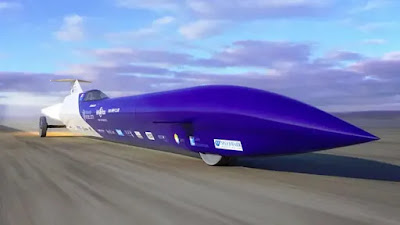
Just so you can see what are the fastest ones out there, here's a few of the upcoming challengers...these are cool looking!

Aussie Invader 5R
https://landspeedrecord.org/aussie-invader-5r-rosco-mcglashan/

Bloodhound SLR
https://landspeedrecord.org/bloodhound-lsr-andy-green/

...and some past record holders....

Thrust 2 - 633.468 mph (1019.468 km/h)


The Blue Flame - 622.407 mph  (1,001.667 km/h)


The Green Monster - 576.553 mph (927.847 km/h). Green?


Wingfoot Express -  413.199 mph (664.963 km/h)


So, we drove out on a paved road to the end, where I was really disappointed as I thought we would be able to go way out on the flats. But then, off in the distance, we saw, what we thought were small ATV-type vehicles coming towards us. As they got closer, we realized that they were CARS! We spotted them first about 10 miles out!

See the "dots" out to the left of the island?


Closer now

Even closer


And almost here...

Once that lead car got onto the pavement, I went over and asked if it was okay to drive out there...was it soggy or wet or do I need 4-wheel drive? They said, "No", it's fine. We went out about 20 miles".

Well, that settled it for us. Off we went!

This is about 5 miles from the paved road.


Waaaay out there now.

Mom and son out biking....3 miles from the road!

You cannot tell, but that is a family of six getting out of their car.


Kim and Katie....obviously !

One last set of photos to show some perspective on how large this salt flat lake is...


Overall aerial to show the star where we started.

Then we drove off the highway to the "launch point".

This is where we saw the "dots" on the horizon looking to the upper right.

...and where we drove out onto the flats and where we ended up. HUGE !


Oh, one more thing...check out what the truck looked like after we got back to the car wash...


This was a pretty neat adventure and one that we'll remember for a long time. Thanks for viewing!

steve/kim/katie

Kim with here sleeping dog, Katie, and some desert rat she picked up !


Monday, May 3, 2021

Twin Falls, Idaho

Twin Falls will be the largest city we visit this month with over 51,000 people. We thought this would be a nice first stop to get our coach organized as it's only about 165 miles from our home....and boy....did we organize! Well, Kim has done most of it while I slept in....zzzzzzzzzzzz.

The big attraction in Twin Falls is the Shoshone Falls. Here's a few photos of when the Snake River is really flowing over the falls and some with very little.

Springtime runoff

We went here in the Fall to see the falls. I forgot that there's very little river flow during the autumn. Duh!


We went one time when there was so much mist we could hardly see the falls....but...


...but it made for some terrific rainbows.

The wind was blowing around 25mph. You can see how it is pushing the falls to the side.

Here's the overlook where you can view from above.


Shoshone Falls is 212 high which is 36" higher than Niagara Falls and flows over a rim 900 feet wide. Niagara Falls is 185 feet and is 1,060 feet wide. 

The flow of the Shoshone Falls is dependent on many variables. One of which is the amount of snowfall our region receives each winter. On years with heavy snowfalls, Shoshone Falls can reach flows upwards of 20,000 CFS (cubic feet per second). In a typical year, the spring flows at Shoshone Falls will peak between 10,000 and 12,000 CFS. To compare....Niagara Falls has Avg. Volume: 85,000 CFS.


The Snake River serves as the lifeblood of our region. Harnessing the water from the Snake River for irrigation is a crucial part of our local economy. Twenty miles upstream, the water is diverted to irrigate over 500,000 acres of farmland. It is estimated that the crops produced in these fields are worth $62,000,000 annually.

Chobani factory
Chobani (formerly Agro Farma) opened its new state-of-the-art yogurt manufacturing plant in Twin Falls, Idaho, US, in December 2012. Spread over an area of one million ft², which is equivalent to 20 football fields, it is the largest yoghurt production facility in the world. An investment of $450m was made in the facility.

We called to see if could get a tour but they don't have any. Rats.

We did not expect to see this in Twin Falls....it was right down the street from our RV park.


Chobani’s yoghurt is the best-selling yoghurt brand in the US. The new Twin Falls facility will help Chobani to increase its presence in the western part of the US and enable it to bring its products faster into the market. It will also enable the company to launch new product innovations.

The plant will use four to five million pounds of milk every day to produce 2.4 million cases of Greek yogurt per week.


We buy their yoghurt because we like to support the local products.

Once upon a time there was a shepherd
In 2005, Hamdi took a loan from the Small Business Administration, bought an old yogurt plant, and brought a small group of passionate individuals together to make the real, wholesome yogurt that he remembered from his childhood. He called the company Chobani, “shepherd” in Turkish, to endow it with the hard-working and compassionate spirit of the mountain farmer.

Perfecting our craft
For the next two years, Hamdi devoted himself to the craft, carefully building his team to ensure quality from the ground up. In 2007, his dream to make delicious, nutritious, natural, and accessible yogurt finally came to fruition, when the very first cup of Chobani® Greek Yogurt hit the shelf.


Pretty neat story.


The Bonneville Flood

Thousands of years ago, the Great Salt Lake in Utah was once called Lake Bonneville and, you can see from the map below, how it almost covered all of western Utah.


Sometime between about 13 and 15 thousand years ago the northernmost arm of massive Lake Bonneville stood against a dam of relatively soft sedimentary rock and alluvium that blocked Red Rock Pass. As Lake Bonneville deepened rapidly at the end of the last ice age the water rose some 400 feet against this unconsolidated rock. At some point, as the planet began its lurch out of the ice age vast Lake Bonneville spilled over this dam. As the waters poured through the mountain pass they quickly ate their way through the 400 feet of softer material until they excavated down to a harder layer of granitic rock and there the lake stabilized for a time.

To compare the flow of the Lake Bonneville Flood....the local Teton Dam Flood had spent itself within 8 or 10 hours, the length of time it took for the reservoir to drain. Additionally, the peak discharge of one million cubic feet per second was only sustained for the first few hours after the dam collapsed and only in the immediate vicinity of the rupture. The distance encompassing serious damage downstream from the dam was perhaps 40 miles, for the flood wave had mostly spent itself by the time it reached Idaho Falls. 

By contrast, the Great Bonneville flood sustained peak discharges of about 40 million cubic feet per second for as long as a year, and the distance over which this peak discharge was maintained was more than 1000 miles.


Here's what the flood did to the Snake River canyon.


You can see the Snake River. Everything to the right and left was scoured by the Lake Bonneville Flood! Over 400 feet high and 70mph!


You can see the canyon walls to the right and left where the flood topped out. Amazing.


We did not know we would see so much in Twin Falls. But, it seems that no matter where we go, there's always more to see than what we believed. Life is grand!

Thank you for following. We'll see you from our next stop.

steve/kim/katie


If we are not watching, Katie likes to chew on the jigsaw pieces. We find them later all mashed up on the floor.


Thursday, April 29, 2021

Let's give Nevada a try

What city do people think of when you mention Nevada? VEGAS....right? Well, no Las Vegas or the other big city, Reno, on this trip. We're going to be desert rats in small towns. 


Here's the population breakdown of the towns we're going to visit: 175 people,  68 people, 182 people, 1176 people, 1807 people, 217 people..

You're asking, "What is there?" 


Bonneville Salt Flats • A spot where you can view the curvature of the earth • Bristlecone Pine Trees that are between 4,000 and 5,000 years old • Wild Burro Refuge • Death Valley • East entrance to Yosemite • Eastern Sierra Nevada mountains • Mono Lake • Bodie Ghost Town • Basque food restaurants • Alabama Hills Rock Formations • tiny BBQ restaurants • Star Wars Canyon....and much more!


So....watch for upcoming entries as we poke around the great state of Nevada !


steve/kim/katie


Monday, March 8, 2021

Getting eager to take off again!

 It's early March and the winter is finally starting to relax it's hold on us. Weather is in the 50's, almost getting into the 60's ! 


One thing nice about the winter....we get great views from our deck during the morning...and afternoon....


...and, yes, we got some snow....


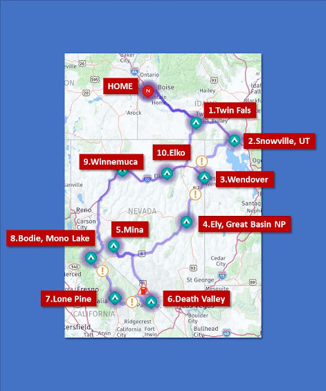
We're getting cabin fever and are itching to get back out on the road but we have doctor's appointments in late April, so May looks like when we will start. I think we'll do some northern Nevada as a shake-down cruise before our serious summer travels. Here's our route so far...


We'll see Shoshone Falls, the curvature of the earth at Wendover, the Great Basin National Park from Ely, Death Valley for 4 days, watch the jets fly through Star Wars Canyon (see link below),see the best ghost town in the states...Bodie, California... kayak on Mono Lake, see some friends in the different cities, then home. One month.

Watch these jets  at Star Wars Canyon just west of Death Valley!

We'll be posting so, if you're interested, take a peek.


So glad when this masking is all over....


steve/kim/katie


Sunday, October 25, 2020

HOME for the winter

 A great summer trip is behind us now and back home to spend the winter. Here's a map of our five-month travels...


Five months. 37 Stops ! ....and many experiences, locations, and sites along the way.


Just a few of the Highlights:
  • Glacial Lake Missoula
  • Kayaking in Lake McDonald at Glacier National Park
  • Theodore Roosevelt National Park car trip in North Dakota
  • Staying at a yacht harbor in Duluth, Minnesota
  • Cheese, cheese, cheese in Wisconsin!
  • Iowa state capitol in Des Moines
  • Custer State Park in South Dakota
  • Elk in Yellowstone National Park, Wyoming
  • Kayaking under the Grand Teton Mountains, Wyoming


Grand Tetons, Wyoming


Lake McDonald, Glacier NP, Montana

Tetons from the kayak...spectacular!

Lower Falls on the Yellowstone River


CHEESE in Wisconsin!!!


Male Elk in the Madison River, Yellowstone NP


Elk. Male, Female and young ones hunkered down in the grass upper right

Sunset in Iowa


We hope you enjoyed our journeys as much as we did. I apologize for not posting more entries along the way....we sure saw some wonderful things....maybe next trip. 

We celebrated our 30th Anniversary on this trip!


Katie keeping watch.